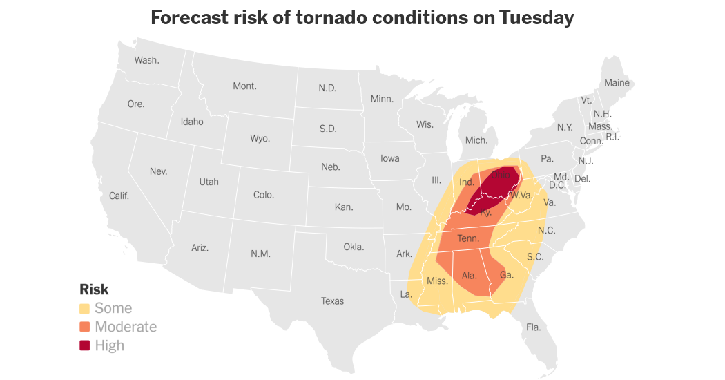
People across much of the Ohio Valley were bracing for severe weather, including thunderstorms and tornadoes, through the afternoon and evening on Tuesday, the National Weather Service said.
Ohio and Kentucky, and parts of Indiana, West Virginia, Tennessee, Alabama, Mississippi and Georgia were likely to be affected, officials said. Forecasters predicted several tornadoes, damaging winds that could reach hurricane-force level, and even hail as large as baseballs.
More than 3.6 million people were under a tornado watch early Tuesday afternoon, the bulk of them around Nashville, according to weather officials. A number of schools in Tennessee either were closed or sent students home early on Tuesday, and some canceled after-school activities, according to local media reports.
Parts of Kentucky and Tennessee were under a tornado watch until 3 p.m. local time, according to the Louisville office of the National Weather Service. Likely conditions in those areas include a few tornadoes, hail up to the size of ping pong balls, and wind gusts of up to 75 miles per hour. Parts of western West Virginia were also under a tornado watch on Tuesday, according to weather officials there.
Flooding was also possible through the evening, forecasters said.
Weather officials encouraged people living in areas where a tornado watch is escalated to a tornado warning to move to a safe place, “ideally in a basement or interior room on the lowest floor of a sturdy building.”
The severe weather is part of a powerful storm system that was moving east after hitting parts of Missouri, Oklahoma and Texas on Monday evening. Around 24 million people faced an enhanced risk of severe weather on Monday, according to the Weather Service.
Forecasters on Monday faced an outage that affected a key part of the nation’s weather tracking system, potentially making it harder for them to warn people about severe weather. The service had returned to normal by 6:30 a.m. Eastern time on Tuesday.


